Datei:Lake Tiberias (Sea of Galilee), Northern Israel.jpg
Größe dieser Vorschau: 398 × 599 Pixel. Weitere Auflösungen: 159 × 240 Pixel | 319 × 480 Pixel | 510 × 768 Pixel | 680 × 1.024 Pixel | 1.440 × 2.168 Pixel.
Originaldatei (1.440 × 2.168 Pixel, Dateigröße: 1,15 MB, MIME-Typ: image/jpeg)
,_Northern_Israel.jpg)
Beschreibung
| Beschreibung |
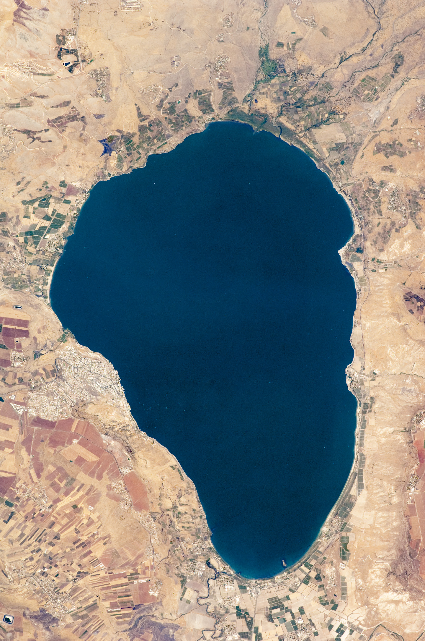
English: Israel’s largest freshwater lake, Lake Tiberias, is also known as the Sea of Tiberias, Lake of Gennesaret, Lake Kinneret, and the Sea of Galilee. The lake measures just more than 21 kilometres north-south, and it is only 43 meters deep. The lake is fed partly by underground springs related to the Jordan sector of the Great Rift Valley, but most of its water comes from the Jordan River, which enters from the north. The river’s winding course can be seen draining the south end of the lake at image bottom. Angular green and brown field patterns clothe most hillsides in this arid landscape. Bright roof tops are the hallmark of several villages in the area. The largest grouping of bright roofs and city blocks indicates the location of Tiberias (named for the Roman Emperor Tiberius), visible at image left on the south-western shore of the lake.
|
||||||||||||||||||||||||||||||||||||||||||||||||||
| Datum | |||||||||||||||||||||||||||||||||||||||||||||||||||
| Quelle | NASA Earth Observatory | ||||||||||||||||||||||||||||||||||||||||||||||||||
| Urheber | This image was taken by the NASA Expedition 20 crew. | ||||||||||||||||||||||||||||||||||||||||||||||||||
| Andere Versionen | Abgeleitete Werke dieser Datei: (Sea of Galilee Northern Israel-2.jpg | ||||||||||||||||||||||||||||||||||||||||||||||||||
Image acquired with a Nikon D2Xs digital camera fitted with an 400 mm lens, and is provided by the ISS Crew Earth Observations experiment and Image Science & Analysis Laboratory, Johnson Space Centre.
Lizenz
| Diese Datei ist gemeinfrei (public domain), da sie von der NASA erstellt worden ist. Die NASA-Urheberrechtsrichtlinie besagt, dass „NASA-Material nicht durch Urheberrecht geschützt ist, wenn es nicht anders angegeben ist“. (NASA-Urheberrechtsrichtlinie-Seite oder JPL Image Use Policy). | ||
 |
Warnung:
|
Dateiversionen
Klicke auf einen Zeitpunkt, um diese Version zu laden.
| Version vom | Vorschaubild | Maße | Benutzer | Kommentar | |
|---|---|---|---|---|---|
| aktuell | 11:32, 14. Sep. 2009 | | 1.440 × 2.168 (1,15 MB) | wikimediacommons>Originalwana | {{Information |Description={{en|1=Israel’s largest freshwater lake, Lake Tiberias, is also known as the Sea of Tiberias, Lake of Gennesaret, Lake Kinneret, and the Sea of Galilee. The lake measures just more than 21 kilometres north-south, and it is |
Dateiverwendung
Die folgende Seite verwendet diese Datei:
,_Northern_Israel.jpg)