Datei:Carningli hillfort.jpg

Originaldatei (2.598 × 1.540 Pixel, Dateigröße: 626 KB, MIME-Typ: image/jpeg)
Beschreibung
| Beschreibung |
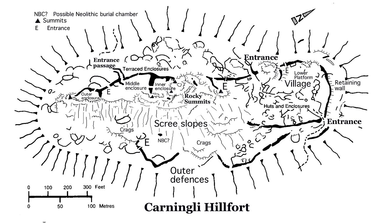
English: Recent field mapping by Brian John, and extraction of data from aerial photos and older published sources, including Hogg 1973. Because of the large number of visitors to this site, the publication of this map could be very helpful to those who want to know more about the hillfort.
The hillfort is on the summit of Carningli, close to Newport in North Pembrokeshire. The site lies within an SSSI. It is widely assumed that the hillfort is from the Iron Age, from the first millennium BC. But some authorities think that it may date from the Bronze Age, since there are many traces of Bronze Age settlement on the surrounding common. There are impressive defensive embankments on all sides of the fort, made of boulders and stones of local dolerite collected from the scree banks. In places the embankments must originally have been up to 3m high, but some have been slighted. There are two main parts to the fort. In the SW there are three heavily defended enclosures, possibly used for keeping animals at times of tribal conflict. On the NE flank of the hill (the lee side) there is a substantial "village" settlement, with the remains of around 25 dwellings on a series of stepped natural platforms. Mostly the dwellings were circular, but some were rectangular. On the E side of the mountain, below the scree slopes, there are two massive outer defensive walls. There are at least seven entrances through the defensive walls. Here and there natural crags and cliff faces have been used as defensive features. Inside and outside the defences there are hundreds of walls and little embankments which show that there was extensive use of the area for animal enclosures, storage huts, paddocks, small fields, gardens etc. Some enclosures are terraced. Many remain to be mapped. Beneath the scree slope on the southern side of the mountain there is a massive flat dolerite slab supported on several boulders. It may be natural -- but it looks suspiciously like some of the crude "sub-Neolithic" burial chambers seen in other parts of Pembrokeshire....... if it is really a burial site, this would push the first use of the mountain back from the Bronze Age into the Neolithic. See more about Carningli here on the Wikipedia site: Mynydd Carningli |
| Datum | 9. April 2007 (Original-Hochladedatum) |
| Quelle | Übertragen aus en.wikipedia nach Commons. |
| Urheber | Der ursprünglich hochladende Benutzer war Brianjohn in der Wikipedia auf Englisch |
Lizenz
- Dieses Werk darf von dir
- verbreitet werden – vervielfältigt, verbreitet und öffentlich zugänglich gemacht werden
- neu zusammengestellt werden – abgewandelt und bearbeitet werden
- Zu den folgenden Bedingungen:
- Namensnennung – Du musst angemessene Urheber- und Rechteangaben machen, einen Link zur Lizenz beifügen und angeben, ob Änderungen vorgenommen wurden. Diese Angaben dürfen in jeder angemessenen Art und Weise gemacht werden, allerdings nicht so, dass der Eindruck entsteht, der Lizenzgeber unterstütze gerade dich oder deine Nutzung besonders.
Ursprüngliches Datei-Logbuch
| Version vom | Maße | Benutzer | Kommentar |
|---|---|---|---|
| 2007-04-09 08:01 | 2598×1540× (641494 bytes) | Brianjohn | Recent field mapping by Brian John, and extraction of data from aerial photos and older published sources, including Hogg 1973. Because of the large number of visitors to this site, the publication of this map could be very helpful to those who want to k |
Dateiversionen
Klicke auf einen Zeitpunkt, um diese Version zu laden.
| Version vom | Vorschaubild | Maße | Benutzer | Kommentar | |
|---|---|---|---|---|---|
| aktuell | 00:36, 17. Nov. 2014 | | 2.598 × 1.540 (626 KB) | wikimediacommons>Hogweard | Transferred from en.wikipedia |
Dateiverwendung
Die folgende Seite verwendet diese Datei: