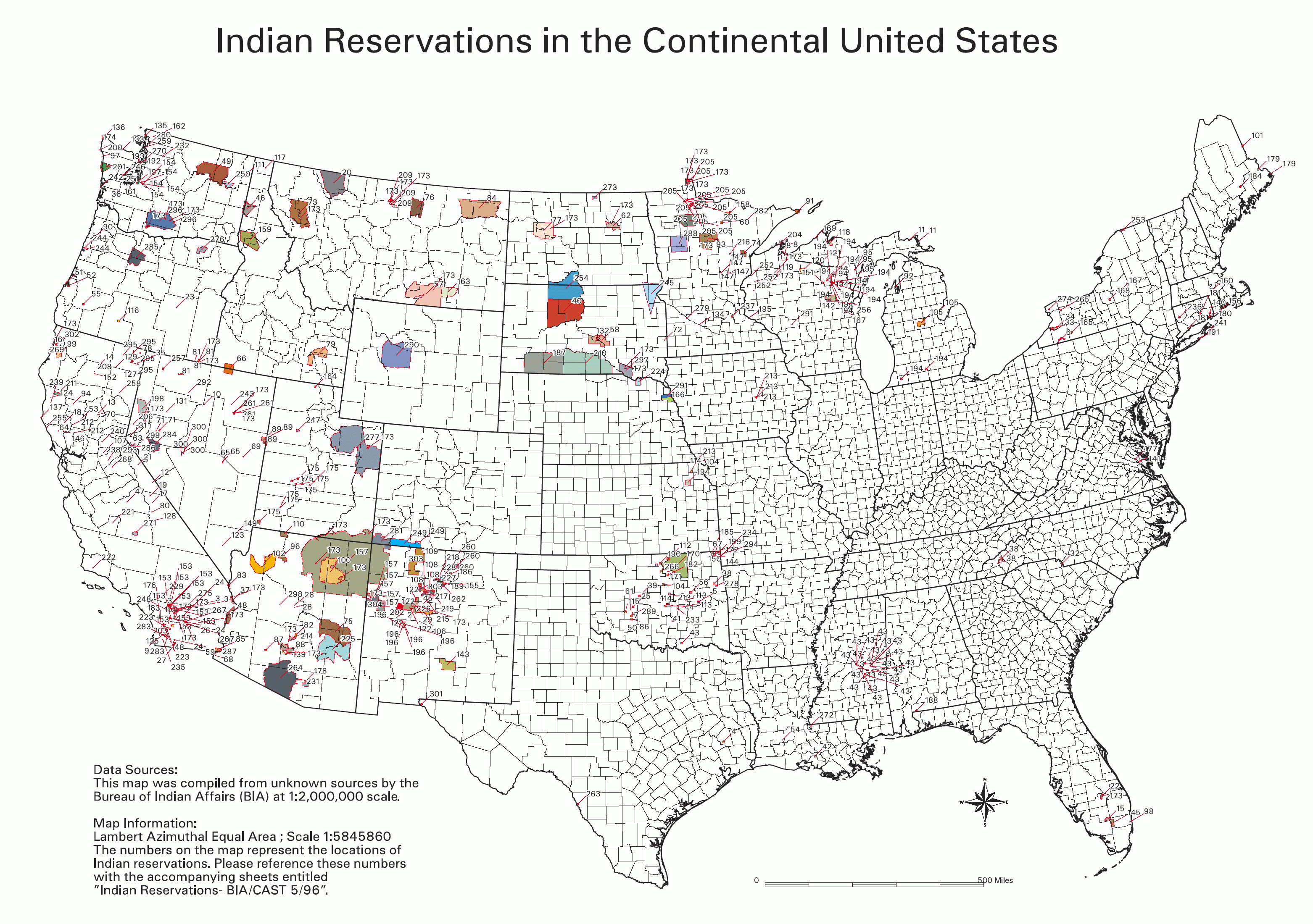
Datei:Bia-map-indian-reservations-usa.png
Größe dieser Vorschau: 800 × 563 Pixel. Weitere Auflösungen: 320 × 225 Pixel | 640 × 451 Pixel | 1.024 × 721 Pixel | 1.280 × 901 Pixel | 2.560 × 1.803 Pixel | 3.124 × 2.200 Pixel.
Originaldatei (3.124 × 2.200 Pixel, Dateigröße: 457 KB, MIME-Typ: image/png)

|
Dieses Bild des Typs Ethnographic map sollte als Vektorgrafik im SVG-Format neu erstellt werden. Vektorformate haben zahlreiche Vorteile; weitere Information unter Commons:Media for cleanup. Wenn dir eine SVG-Version dieses Bildes vorliegt, so lade diese bitte hoch. Nach dem Hochladen der Datei ist diese Vorlage auf der aktuellen Bildbeschreibungsseite durch die Vorlage {{Vector version available}}, oder kürzer {{Vva}}, zu ersetzen. Es ist empfohlen die neue SVG-Datei „Bia-map-indian-reservations-usa.svg“ zu nennen – dann benötigt die Vorlage vector version available (bzw. vva) keinen Parameter.
|

|
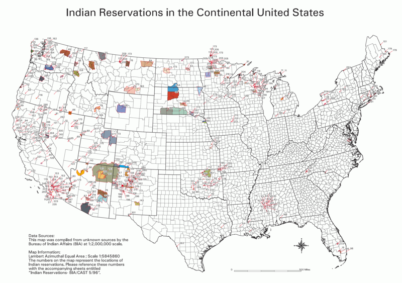
Diese Datei wurde durch File:Indian reservations in the Continental United States.png ersetzt. Es wird empfohlen, die andere Datei zu verwenden. Bitte beachte, dass das Löschen ersetzter Bilder einer Löschdiskussion bedarf. Grund: „Updated to include newly-established reservations“
|

|
Source
- National Park Service; see also: Bureau of Indian Affairs
Key
- 0 No Data
- Absentee Shawnee
- Acoma
- Agua Caliente
- Alabama-Coushatta
- Alabama-Quassarte Creeks
- Allegany
- Apache
- Bad River
- Barona Ranch
- Battle Mountain
- Bay Mills
- Benton Paiute
- Berry Creek
- Big Bend
- Big Cypress
- Big Lagoon
- Big Pine
- Big Valley
- Bishop
- Blackfeet
- Bridgeport
- Brighton
- Burns Paiute Colony
- Cabezon
- Caddo
- Cahuilla
- Campo
- Camp Verde
- Canoncito
- Capitan Grande
- Carson
- Catawba
- Cattaraugus
- Cayuga
- Cedarville
- Chehalis
- Chemehuevi
- Cherokee
- Cheyenne-Arapahoe
- Cheyenne River
- Chickasaw
- Chitimacha
- Choctaw
- Citizen Band Of Potawatomi
- Cochiti
- Coeur D'alene
- Cold Springs
- Colorado River
- Colville
- Comanche
- Coos, Lower Umpqua & Siuslaw
- Coquille
- Cortina
- Coushatta
- Cow Creek
- Creek
- Crow
- Crow Creek
- Cuyapaipe
- Deer Creek
- Delaware
- Devils Lake
- Dresslerville Colony
- Dry Creek
- Duckwater
- Duck Valley
- Eastern Shawnee
- East Cocopah
- Ely Colony
- Enterprise
- Fallon/Stillwater
- Flandreau Indian School
- Flathead
- Fond Du Lac
- Fort Apache
- Fort Belknap
- Fort Berthold
- Fort Bidwell
- Fort Hall
- Fort Independence
- Fort Mcdermitt
- Fort Mcdowell
- Fort Mohave
- Fort Peck
- Fort Yuma
- Ft. Sill Apache
- Gila Bend
- Gila River
- Goshute
- Grande Ronde
- Grand Portage
- Grand Traverse
- Greater Leech Lake
- Grindstone
- Hannahville
- Havasupai
- Hoh
- Hollywood
- Hoopa Valley
- Hopi
- Houlton Maliseets
- Hualapai
- Inaja
- Iowa
- Isabella
- Isleta
- Jackson
- Jemez
- Jicarilla
- Kaibab
- Kalispel
- Kaw
- Kialegee Creek
- Kickapoo
- Kiowa
- Klamath
- Kootenai
- L'anse
- Lac Courte Oreilles
- Lac Du Flambeau
- Lac Vieux Desert
- Laguna
- Las Vegas
- Laytonville
- La Jolla
- La Posta
- Likely
- Lone Pine
- Lookout
- Los Coyotes
- Lovelock Colony
- Lower Brule
- Lower Elwah
- Lower Sioux
- Lummi
- Makah
- Manchester
- Manzanita
- Maricopa
- Mashantucket Pequot
- Mattaponi
- Menominee
- Mescalero
- Miami
- Miccosukee
- Middletown
- Mille Lacs
- Mission
- Moapa
- Modoc
- Mole Lake
- Montgomery Creek
- Morongo
- Muckleshoot
- Nambe
- Narragansett
- Navajo
- Nett Lake
- Nez Perce
- Nipmoc-Hassanamisco
- Nisqually
- Nooksack
- Northern Cheyenne
- Northwestern Shoshone
- Oil Springs
- Omaha
- Oneida
- Onondaga
- Ontonagon
- Osage
- Otoe-Missouri
- Ottawa
- Out
- Ozette
- Paiute
- Pala
- Pamunkey
- Pascua Yaqui
- Passamaquoddy
- Paucatauk Pequot
- Paugusett
- Pawnee
- Pechanga
- Penobscot
- Peoria
- Picuris
- Pine Ridge
- Poarch Creek
- Pojoaque
- Ponca
- Poosepatuck
- Port Gamble
- Port Madison
- Potawatomi
- Prairie Isle
- Puertocito
- Puyallup
- Pyramid Lake
- Quapaw
- Quillayute
- Quinault
- Ramah
- Ramona
- Red Cliff
- Red Lake
- Reno-Sparks
- Rincon
- Roaring Creek
- Rocky Boys
- Rosebud
- Round Valley
- Rumsey
- Sac And Fox
- Salt River
- Sandia
- Sandy Lake
- Santa Ana
- Santa Clara
- Santa Domingo
- Santa Rosa
- Santa Rosa (North)
- Santa Ynez
- Santa Ysabel
- Santee
- San Carlos
- San Felipe
- San Ildefonso
- San Juan
- San Manual
- San Pasqual
- San Xavier
- Sauk Suiattle
- Seminole
- Seneca-Cayuga
- Sequan
- Shagticoke
- Shakopee
- Sheep Ranch
- Sherwood Valley
- Shingle Spring
- Shinnecock
- Shoalwater
- Shoshone
- Siletz
- Sisseton
- Skokomish
- Skull Valley
- Soboba
- Southern Ute
- Spokane
- Squaxon Island
- St. Croix
- St. Regis
- Standing Rock
- Stewarts Point
- Stockbridge Munsee
- Summit Lake
- Susanville
- Swinomish
- Taos
- Te-Moak
- Tesuque
- Texas Kickapoo
- Tohono O'odham
- Tonawanda
- Tonikawa
- Torres Martinez
- Toulumne
- Trindad
- Tulalip
- Tule River
- Tunica-Biloxi
- Turtle Mountains
- Tuscarora
- Twentynine Palms
- Umatilla
- Uintah And Ouray
- United Keetoowah Band Of Cherokee
- Upper Sioux
- Upper Skagit
- Ute Mountain
- Vermilion Lake
- Viejas
- Walker River
- Warm Springs
- Washoe
- West Cocopah
- White Earth
- Wichita
- Wind River
- Winnebago
- Winnemucca
- Woodford Indian Community
- Wyandotte
- Xl Ranch
- Yakama
- Yankton
- Yavapai
- Yerington
- Yomba
- Ysleta Del Sur
- Yurok
- Zia
- Zuni
Info contained in image
Data Sources: This map was compiled from unknown sources by the Bureau of Indian Affairs (BIA) at 1:2,000,000 scale.
Map Information: Lambert Azimuthal Equal Area; Scale 1:5845860 The numbers on the map represent the locations of Indian reservations. Please reference these numbers with the accompanying sheets entitled Indian Reservations - BIA/CAST 5/96
Beschreibung
English: BIA map of Indian Reservations in the Continental United States. An index to the reservations of the map can be found on the National NAGPRA site, http://www.cr.nps.gov/nagpra/. That key is currently at http://www.nps.gov/history/nagpra/documents/ResMapIndex.htm.
Lizenz
| Diese Datei ist ein Werk eines Mitarbeiters des National Park Service (NPS) der Vereinigten Staaten, aufgenommen oder hergestellt während seiner offiziellen Anstellung. Als ein amtliches Werk der Bundesregierung der Vereinigten Staaten ist dieses Bild gemeinfrei. (Nähere Informationen dazu sind auf der offiziellen Website des NPS verfügbar.) |
derivative works
Abgeleitete Werke dieser Datei:
Dateiversionen
Klicke auf einen Zeitpunkt, um diese Version zu laden.
| Version vom | Vorschaubild | Maße | Benutzer | Kommentar | |
|---|---|---|---|---|---|
| aktuell | 01:06, 1. Feb. 2006 | | 3.124 × 2.200 (457 KB) | wikimediacommons>Wille Raab~commonswiki | BIA map of Indian Reservations in the Continental United States. An index to the reservations of the map can be found on the National NAGPRA site, http://www.cr.nps.gov/nagpra/. |
Dateiverwendung
Die folgende Seite verwendet diese Datei: